
El Niño Is No Longer a Forecast. For MENA and Africa, It’s a Portfolio Event.
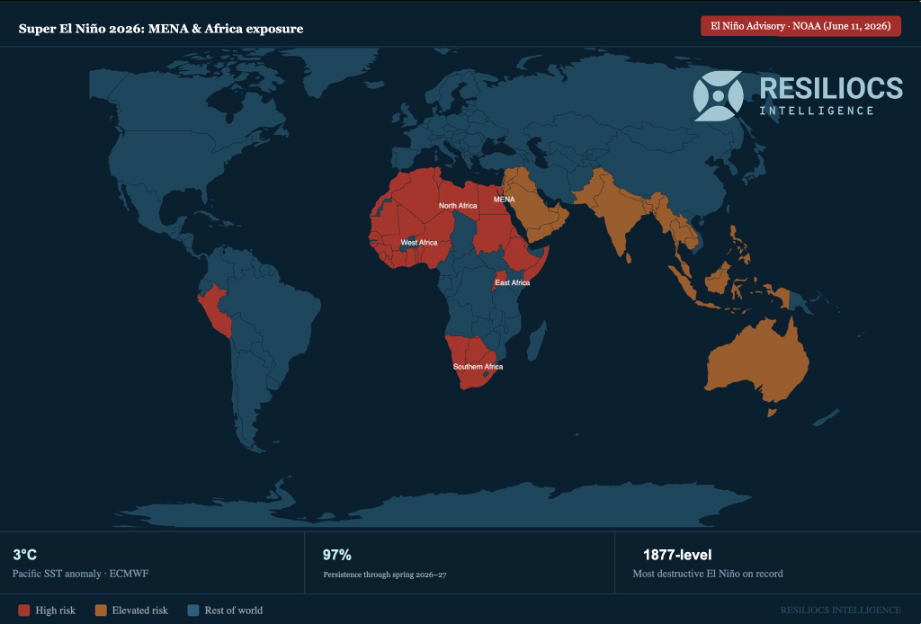
El Niño is no longer a forecast. On June 11, 2026, NOAA moved its official status from Watch to Advisory. That shift means the event is no longer expected. It is confirmed and present in the tropical Pacific. What sat at an 82% probability in May is now observed reality.
The July 9 update pushed the story further. NOAA now assigns an 81% probability that the current event ranks among the strongest since records began in 1950, and a 97% probability it persists through early spring 2027. Europe’s leading weather agency (ECMWF) projects Pacific sea surface temperatures will run 3°C above normal by year-end, a level the Pacific has not reached in living memory.
Super El Niño is a global event. Elevated exposure runs from the Pacific through South Asia, Southeast Asia, Australia, and parts of South America. This analysis focuses on MENA and Africa for two reasons. These regions carry a compound risk profile (infrastructure designed against climate baselines that no longer hold, thin fiscal buffers to absorb simultaneous shocks). And this is where the exposure sits least priced-in by insurance markets, disclosure frameworks, and underwriting models. For asset owners across these regions, what’s now confirmed is a portfolio stress test that has not been reflected in capex planning.
The real risk isn’t the heat itself. It’s the chain reaction that follows. A Super El Niño rewires weather patterns across the planet. Seasonal rains that farms and power grids depend on arrive late or fail. Some regions get sudden, destructive downpours. Others fall into deep drought that water systems were never built to handle.
What makes this cycle different is that it lands on top of two conditions that weren’t present at this scale in earlier events. Cities are denser than ever, so a single event moves through more people, more assets, and more balance sheets at once. And the asset portfolios investors and operators depend on (energy, water, real estate, ports, and supply chains) were built and underwritten against climate baselines that no longer hold.
Cities across Egypt, the Gulf (Saudi Arabia, UAE), and the Levant were built for a climate that no longer exists. Drainage systems were sized for lighter rainfall, so flash floods in dry cities cause outsized damage. Heat waves push cooling demand past what power grids were built to deliver, leading to blackouts, shortened equipment life, and stranded capex.
The financial picture makes it worse. Regional governments have limited room in their budgets to absorb climate and economic shocks at the same time. When public buffers run thin, the cost lands on asset owners through higher insurance premiums, deferred maintenance bills, and lost revenue at the asset level.
Sub-Saharan and East Africa face a different mix of risks with similar severity. Grids in Ethiopia, Kenya, and Tanzania rely on hydropower, which weakens during prolonged drought and slows industrial output and cold chains. Agricultural supply chains face repeated disruption across planting seasons. Coastal assets in West Africa and along the MENA coast face stronger storm surges and flooding on top of decades of underinvestment in infrastructure.
The 1877 to 1878 El Niño triggered famines across Africa and Asia that killed an estimated 30 to 60 million people. The comparison isn’t about the death toll. It’s about the physics. The Pacific hasn’t been this warm since. But the 2026 event arrives in a world with denser cities, larger asset portfolios, and balance sheets that were never tested against a shock this size.
The forecast exists. The regional climate models exist. Asset-level risk data exists. What has been missing, whether in MENA, Africa, or anywhere the current El Niño signal is strong, is the intelligence layer that turns those inputs into portfolio-specific loss estimates: which substations, grid segments, coastal assets, and agricultural offtake contracts sit inside the highest-probability impact zones over the next 6 to 18 months. Resiliocs Intelligence was built for this problem, combining climate models with asset-level engineering to produce quantified exposure and adaptation pathways for any portfolio exposed to this event, wherever it operates.
Every previous Super El Niño arrived in a world with lower asset density, thinner insurance penetration, and shorter reporting horizons. This one doesn’t. The forecast has moved from probability to advisory to strength ranking in less than 60 days. The choice now is whether to price this event into your portfolio before it lands, or absorb it after.
Note: El Niño occurs when equatorial Pacific sea surface temperatures rise at least 0.5°C above the long-term average for three consecutive months. A “Super” event exceeds 2°C above average, a threshold that fundamentally reorganizes global weather systems. ECMWF is currently projecting +3°C above average by year-end 2026.
Sources: NOAA Climate Prediction Center ENSO Diagnostic Discussion (June 11 and July 9, 2026); ECMWF seasonal forecast; IRI ENSO Quick Look.
https://stormbag.co/blogs/stormbag-flood-protection-blog/super-el-nino-2026-27-what-noaas-off-the-charts-forecast-means-for-the-year-ahead
https://watchers.news/2026/07/10/el-nino-strengthens-81-chance-of-becoming-one-of-the-strongest-on-record-by-late-2026/
